


وصف لـ Horizon Explorer AR
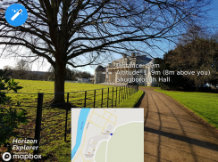
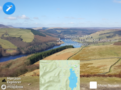
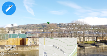
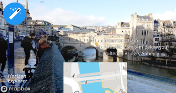
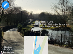
Point your camera at a landmark you can see on the horizon (eg. Hill, Mountain, Road, Lake, Building) and see:
- Name of the landmark
- Distance from you
- Altitude (& relative to you)
- Map of surrounding area
- Nearby towns and cities
- Wikipedia info for any landmark with a Wikipedia page
- Direction from you (eg. Northwest)
- Directions to landmark (opens in google maps)
- Street view for where you're pointing (opens in google maps)
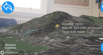
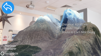
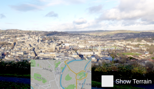
Or use 3D Map mode:
- See terrain laid out in front of you
- Move phone to fly around the map
- Roadmap / satellite / hybrid
- Search & display 3D-maps for anywhere worldwide
- Distance, altitude and landmark names
- Infinite scroll
Horizon Explorer works worldwide, but works best on top of a hill with an unobstructed view of your surroundings. You can drag the horizon line with your finger to line up with the camera if the automatic tracking is not working very well. Or try waving your phone around in the air in a figure 8, then pressing "align using compass" to calibrate the compass.
Live airplanes can also be enabled, starting from $0.99. Point at a plane and see the flight number, origin, destination, altitude and current airspeed of any commercial airline plane you can see.
If you are in a tall building, or otherwise not standing on the ground, enable "Tall Building mode" and optionally set your altitude using the slider.
Horizon Explorer will show mountain names, lakes or forests, the names & designations of roads, and many buildings.
Wikipedia Information will be displayed for anything that has an English Wikipedia article with a location set.
This app uses Google's ARCore to do augmented reality. This technology is currently available on ~50 phones: https://developers.google.com/ar/discover/supported-devices
If you don't already have the latest ARCore app installed, you will be prompted to install / update it from the Play Store when you first open Horizon Explorer.
وجه الكاميرا إلى معلم بارز يمكنك رؤيته في الأفق (على سبيل المثال ، التل ، الجبل ، الطريق ، البحيرة ، المبنى) وانظر:
- اسم المعلم
- المسافة منك
- الارتفاع (بالنسبة لك)
- خريطة للمنطقة المحيطة بها
- البلدات والمدن القريبة
- معلومات ويكيبيديا لأي معلم مع صفحة ويكيبيديا
- اتجاه منك (مثل الشمال الغربي)
- الاتجاهات إلى معلم (يفتح في خرائط جوجل)
- التجوّل الافتراضي للمكان الذي تشير إليه (يفتح في خرائط google)
أو استخدم وضع الخريطة ثلاثية الأبعاد:
- انظر التضاريس وضعت أمامك
- نقل الهاتف ليطير في جميع أنحاء الخريطة
- خارطة الطريق / القمر الصناعي / الهجين
- بحث وعرض الخرائط 3D في أي مكان في جميع أنحاء العالم
- الأسماء عن بعد والارتفاع والأعراق
- التدرج اللانهائي
يعمل Horizon Explorer في جميع أنحاء العالم ، ولكنه يعمل بشكل أفضل على قمة تلة مع إطلالة رائعة على محيطك. يمكنك سحب خط الأفق بإصبعك لتتماشى مع الكاميرا إذا كان التتبع التلقائي لا يعمل جيدًا. أو حاول التلويح بالهاتف في الهواء في شكل 8 ، ثم الضغط على "align with compass" لمعايرة البوصلة.
يمكن أيضًا تمكين الطائرات المباشرة ، بدءًا من 0.99 دولارًا أمريكيًا. نقطة في طائرة ورؤية رقم الرحلة ، والأصل والوجهة والارتفاع والسرعة الجوية الحالية لأي طائرة طيران تجارية يمكنك أن ترى.
إذا كنت في مبنى مرتفع ، أو لا تقف على الأرض ، فقم بتمكين "وضع المبنى الطويل" وقم بتعيين ارتفاعك اختيارياً باستخدام شريط التمرير.
يعرض Horizon Explorer أسماء الجبال أو البحيرات أو الغابات وأسماء الطرق وتعييناتها والعديد من المباني.
سيتم عرض معلومات Wikipedia لأي شيء يحتوي على مقالة Wikipedia باللغة الإنجليزية مع مجموعة الموقع.
يستخدم هذا التطبيق ARCore جوجل للقيام الحقيقة المدمجة. تتوفر هذه التقنية حاليًا على ~ 50 هاتفًا: https://developers.google.com/ar/discover/supported-devices
إذا لم يكن لديك تطبيق ARCore مثبتًا من قبل ، فستتم مطالبتك بتثبيته / تحديثه من متجر Play عند فتح Horizon Explorer لأول مرة.
Horizon Explorer AR - إصدار 1.23.0
(23-04-2020)Horizon Explorer AR - معلومات APK
نُسخة APK: 1.23.0الحزمة: com.arrowsd.horizonexplorerتطبيقات من الفئة نفسها
قد يعجبك أيضًا...


